
How Microsoft uses Azure Maps Creator

Remote work and sustainability have changed how we use our physical spaces. As a result, there is a growing need to optimize our facilities to support a hybrid workforce and reduce the environmental impact of where we work. It may seem obvious, but floor plans are vital resources for facilities managers to plan physical space usage. Moving from a static representation to an interactive indoor mapping solution enables building managers to assess available space and equipment, respond to critical issues, and adapt to the demands of hybrid workplaces instantly while reducing their overall carbon footprint.
Microsoft has many diverse workspaces worldwide. These are places where we work and where we welcome customers and partners. Not only do we strive to create the best experience when visiting our buildings, but we also look to showcase what is possible with our technology. Microsoft has committed to improving the world through our sustainability efforts, meaning we measure all kinds of things, like temperature, energy usage, and occupation in our buildings. To get the best employee and visitor experience, we use many IoT sensors in our facilities to reduce energy consumption and provide indoor navigation. Our Digital Workplace team engineered floorplans and data pipelines using Azure Digital Twins and the Azure Maps platforms to help make this all possible.

Consider a hybrid employee deciding whether to travel to the office on a typical day. Do they have a face-to-face meeting at the office, or can they attend remotely using Microsoft Teams? What is the difference in time and impact of traveling by car versus saving energy by taking a shared commute option like carpool, Microsoft shuttle, or public bus service? If arriving by car, will parking be available? The larger question for what is being called “Green Commute” is, if I must get to the office, what is the most efficient option, in both time and energy?
At Microsoft, we use innovative technology to help make this a more effortless experience for our employees. For example, when you arrive at one of our buildings, you can use a kiosk with an interactive map showing the floor plans and offering guidance to find the route to your meeting location, a person, or a specific location within that building. If you are fitness minded, you may even choose to navigate to your next location by using the stairs instead of an elevator. Do you have a last-minute meeting? You can instantly search for available meeting rooms nearby and reserve it at the kiosk or on your mobile phone.
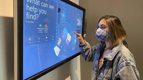
This image highlights a Microsoft kiosk showing an interactive map built using the Azure Maps geospatial mapping platform. Azure Maps Creator offers the ability to onboard and render a floor plan as an interactive indoor map.
Check out more articles in our Azure Maps Tech Blog, to find out more about Azure Maps Creator and its capabilities.
Published on:
Learn moreRelated posts
Introducing the Data-Bound Reference Layer in Azure Maps Visual for Power BI
Imagine managing a nationwide sales team and needing to understand how your sales align with factors like population density, competitor locat...
Enhance Azure Maps with Overture Maps Data using PMTiles!
Supercharge Azure Maps with Overture Maps Data using PMTiles! We’ve got some exciting news. Azure Maps now supports PMTiles! This me...
Where do I go if I have questions about Azure Maps?
As you might expect, just looking around on your own, or asking Co-pilot, you can find comprehensive help like Samples.AzureMaps.com, wit...
Tailor your Reference Layers in Azure Maps Visual for Power BI
We’re excited to share the latest enhancements to the Azure Maps visual in Power BI, designed to make your data visualization even mor...
Enhancing Logistics with Azure Maps and NVIDIA cuOpt for Multi-Itinerary Optimization
The logistics industry is always finding ways to optimize vehicle routing to enhance efficiency. The Vehicle Routing Problem (VRP) and Pickup ...
Introducing the Unified Azure Maps Experience
Microsoft has recently announced the unification of Bing Maps for Enterprise (BME) with Azure Maps, marking a remarkable advancement in their ...
Power BI Azure Maps Visual: Enhanced Reference Layer & Embedded Support
The Power BI Azure Maps visual has received a major update which includes an expansion of the reference layer and the addition of Power BI Emb...
Enhance your indoor maps with real-time map feature styling
The ability to dynamically update and visualize the state of rooms or areas within a building is critical to understanding the status of any b...
Dynamic Clustering Aggregation with Custom Styling in Bubble Layer
The Power BI Azure Maps visual allows you to create stunning geospatial visualizations with your data. Today, we are excited to announce a new...
HO HO HO Two Point OH!
You might notice some big changes have come to the North Pole experience at NORADSanta.ORG this year. Developer elves have implemented a...