Azure Maps Weather Services adds three new services

Azure Maps Weather Services, which became generally available in April 2021, has added three new services, Historical Weather, Air Quality, and Tropical Storms. The Azure Maps Weather Services data comes from our leading worldwide weather service provider AccuWeather. The addition of these three new services will empower developers and companies to expand capabilities even further when it comes to weather data.
Historical Weather
The Historical Weather API provides actuals, normals, and records climatology data by day, for a specified date range, up to 31 days in a single API request. Historical data may be available as far back as 5 to 40+ years and includes temperatures, precipitation, snowfall, snow depth, and cooling/heating degree day information, depending on the location and feature.
Historical Weather data enables customers to get past climatology information to analyze and helps to make predictions on future weather conditions and support making informed business decisions. Historical Weather data can be used for many use cases such as forensics, weather studies, and most commonly for business analytics to determine how past weather impacted logistics, sales, and other business scenarios. For example, you can predict what products will sell better by specific weather conditions by adding weather data to your sales records or predicting the best time to change to winter tires for your location.
Air Quality
The Air Quality API provides detailed information about the current and forecasted air pollutants and air quality concentration. Forecasted information is available by the hour (upcoming 1, 12, 24, 48, 72, and 96 hours) and by day (upcoming 1 to 7 days). Information includes pollution levels, air quality index values, dominant pollutants, and a brief statement summarizing risk levels and suggested precautions.
If you are building an outdoor running/cycling app, you can warn your users if the air quality conditions are better in one hour or analyze the impact on your health by tracking what kind of air you breathe. Air Quality info can be used on everything from outdoor sensors, devices used by people while commuting, working, exercising, and other outside activities to indoor use with HVAC and air purifiers or general monitoring of an area.
Tropical Storms
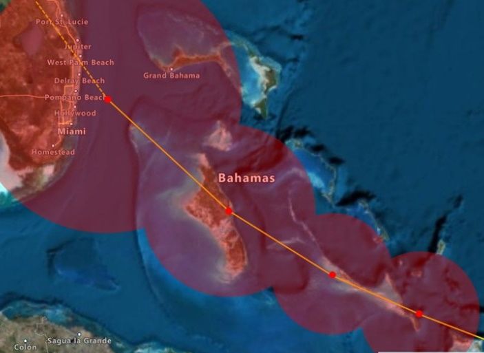
The Tropical Storms API provides information on government-issued active and forecasted tropical storms, the locations (path), and the ability to search government-issued tropical storms by year. Information includes; location coordinates, forecast, creation date, status, geometry, basin ID, window, wind speed, and wind radii. Tropical storms are also known as hurricanes, cyclones, and typhoons, depending on the region of the world.
Tropical Storms info can be used to get useful observational and forecast data on current storms or to research details from previous tropical storm events for business intelligence and public safety purposes.
- Get Tropical Storm Active
- Get Tropical Storm Forecast
- Get Tropical Storm Locations
- Get Tropical Storm Search
Feedback
Visit the Azure Maps portal today to get started, and as always, we look forward to your feedback on our Tech Community site.
Published on:
Learn moreRelated posts
Microsoft Purview: Data Lifecycle Management- Azure PST Import
Azure PST Import is a migration method that enables PST files stored in Azure Blob Storage to be imported directly into Exchange Online mailbo...
How Snowflake scales with Azure IaaS
Microsoft Rewards: Retirement of Azure AD Account Linking
Microsoft is retiring the Azure AD Account Linking feature for Microsoft Rewards by March 19, 2026. Users can no longer link work accounts to ...
Azure Function to scrape Yahoo data and store it in SharePoint
A couple of weeks ago, I learned about an AI Agent from this Microsoft DevBlogs, which mainly talks about building an AI Agent on top of Copil...
Maximize Azure Cosmos DB Performance with Azure Advisor Recommendations
In the first post of this series, we introduced how Azure Advisor helps Azure Cosmos DB users uncover opportunities to optimize efficiency and...
February Patches for Azure DevOps Server
We are releasing patches for our self‑hosted product, Azure DevOps Server. We strongly recommend that all customers stay on the latest, most s...
Building AI-Powered Apps with Azure Cosmos DB and the Vercel AI SDK
The Vercel AI SDK is an open-source TypeScript toolkit that provides the core building blocks for integrating AI into any JavaScript applicati...
Time Travel in Azure SQL with Temporal Tables
Applications often need to know what data looked like before. Who changed it, when it changed, and what the previous values were. Rebuilding t...


